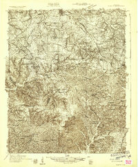
1931 Map of Ridgetop
USGS Topo · Published 1957About this map
The hills and hollows of the Highland Rim north of Nashville are documented here during the early 1930s, revealing a landscape defined by small rural communities and extensive church-centered social life. Significant elevation changes are marked by features like Dividing Ridge and Paradise Ridge, while the Louisville & Nashville RR snakes through the terrain to serve the Ridgetop Sta. The settlement of Springfield sits at the northern edge, but much of the map is a network of country lanes connecting numerous crossroads institutions, from Oakwood Ch and St Lawrence Ch to local education sites such as Crossroads Sch. An early Airway Beacon near Glenview indicates the emerging aviation infrastructure of the era, standing in contrast to the traditional farm-and-creek geography of Sycamore Creek.
Find a feature on this map
62 named features on this map. Tap any name to fly to it.
Don’t see what you’re looking for? This feature index may not catch every label — zoom into the map to look around manually.
Map Details
Editions of this 1931 Ridgetop Map
2 editions found
Other maps of this area

1903 · Nashville
USGS Topo · 1:125,000

1930 · White Bluff
USGS Topo · 1:62,500

1931 · Ridgetop
USGS Topo · 1:62,500

1932 · Hermitage
USGS Topo · 1:62,500

1932 · Nashville
USGS Topo · 1:62,500

1933 · White Bluff
USGS Topo · 1:62,500

1935 · Ridgetop
USGS Topo · 1:62,500

1942 · Gallatin
USGS Topo · 1:100,000

1942 · Lebanon
USGS Topo · 1:100,000

1952 · Goodlettsville
USGS Topo · 1:24,000