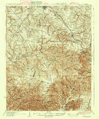
1935 Map of Ridgetop
USGS Topo · Published 1935About this map
The Louisville and Nashville RR cuts through the high ground of northern Tennessee, connecting the commercial centers of Springfield and Greenbrier. This 1935 edition illustrates a landscape of ridges and deep hollows, where small farming communities and country crossroads are centered around landmarks like Gordons Store and Lights Chapel. The terrain is defined by the Dividing Ridge, which separates the northern drainages of the Sulphur Fork Red River from the southern creeks flowing toward the Cumberland.
Find a feature on this map
89 named features on this map. Tap any name to fly to it.
Don’t see what you’re looking for? This feature index may not catch every label — zoom into the map to look around manually.
Map Details
Editions of this 1935 Ridgetop Map
2 editions found
Other maps of this area

1903 · Nashville
USGS Topo · 1:125,000

1930 · White Bluff
USGS Topo · 1:62,500

1931 · Ridgetop
USGS Topo · 1:62,500

1932 · Hermitage
USGS Topo · 1:62,500

1932 · Nashville
USGS Topo · 1:62,500

1933 · White Bluff
USGS Topo · 1:62,500

1935 · Ridgetop
USGS Topo · 1:62,500

1942 · Gallatin
USGS Topo · 1:100,000

1942 · Lebanon
USGS Topo · 1:100,000

1952 · Goodlettsville
USGS Topo · 1:24,000