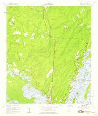
1954 Map of Ridgeville
USGS Topo · Published 1959About this map
Darien and the surrounding marshlands of McIntosh County are captured here in the mid-1950s, showcasing a landscape defined by the winding Altamaha River and its intricate distributaries. The coastal environment is marked by numerous tidal features like Cathead Creek, Potosi Island, and Hird Island. Settlement is concentrated along the Coastal Highway, where community life centered around local congregations such as Bethel Ch, St Andrews Ch, and First African Ch.
Find a feature on this map
60 named features on this map. Tap any name to fly to it.
Don’t see what you’re looking for? This feature index may not catch every label — zoom into the map to look around manually.
Map Details
Editions of this 1954 Ridgeville Map
2 editions found
Other maps of this area

1918 · Everett City
USGS Topo · 1:62,500

1920 · Sapelo River
USGS Topo · 1:62,500

1920 · Everett City
USGS Topo · 1:62,500

1921 · Darien
USGS Topo · 1:62,500

1943 · Ludowici
USGS Topo · 1:62,500

1943 · Sapelo River
USGS Topo · 1:62,500

1944 · Everett City
USGS Topo · 1:62,500

1945 · Sapelo River
USGS Topo · 1:62,500

1946 · Brunswick
USGS Topo · 1:250,000

1948 · Brunswick
USGS Topo · 1:250,000