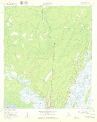
1954 Map of Ridgeville
USGS Topo · Published 1959About this map
Darien and its surrounding tidal marshes anchor this mid-century coastal survey, where the Altamaha River branches into a complex network of creeks and cuts. The landscape is defined by extensive wetlands like Buffalo Swamp and Chisholm Swamp, which isolate various landmasses including Potosi Island and Hird Island. Cultural history is prominently marked by the Tolomato Spanish Mission Ruins and several cemeteries such as St Andrews Cem and King Cem, suggesting deep roots in this Georgia maritime region. Infrastructure of the era is represented by the Coastal Highway and the Old Railroad Grade, which connect smaller settlements like Ridgeville and Meridian. Notable local landmarks include Edenfield Airport and the distinct industrial remnants signaled by the Chimney on Union Island.
Find a feature on this map
65 named features on this map. Tap any name to fly to it.
Don’t see what you’re looking for? This feature index may not catch every label — zoom into the map to look around manually.
Map Details
Editions of this 1954 Ridgeville Map
2 editions found
Other maps of this area

1918 · Everett City
USGS Topo · 1:62,500

1920 · Sapelo River
USGS Topo · 1:62,500

1920 · Everett City
USGS Topo · 1:62,500

1921 · Darien
USGS Topo · 1:62,500

1943 · Ludowici
USGS Topo · 1:62,500

1943 · Sapelo River
USGS Topo · 1:62,500

1944 · Everett City
USGS Topo · 1:62,500

1945 · Sapelo River
USGS Topo · 1:62,500

1946 · Brunswick
USGS Topo · 1:250,000

1948 · Brunswick
USGS Topo · 1:250,000