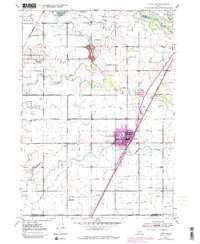
1949 Map of Rigby
USGS Topo · Published 1979About this map
Canals and irrigation networks dominate the landscape around Rigby and Menan in the late 1940s, reflecting a highly developed agricultural system between the Snake River and the volcanic prominence of Little Buttes. The intricate web of waterways, including the Lewisville Canal, Burgess Canal, and the Dry Bed, illustrates the engineering required to sustain Idaho's high-desert farming communities. Regional transportation is anchored by the Union Pacific railroad and the Yellowstone Highway, which pass through the urban center of Rigby. Local landmarks like the Garfield Sch and various local cemeteries provide valuable touchstones for genealogists researching families from the Lorenzo and Annis Slough areas. Revisions to the map also document the expansion of urban residential areas around Rigby, showcasing the town's growth decades after the initial survey.
Find a feature on this map
38 named features on this map. Tap any name to fly to it.
Don’t see what you’re looking for? This feature index may not catch every label — zoom into the map to look around manually.
Map Details
Editions of this 1949 Rigby Map
3 editions found
Other maps of this area

1948 · Rigby
USGS Topo · 1:24,000

1948 · Lewisville
USGS Topo · 1:24,000

1948 · Idaho Falls North
USGS Topo · 1:24,000

1948 · Ucon
USGS Topo · 1:24,000

1949 · Ucon
USGS Topo · 1:24,000

1949 · Idaho Falls North
USGS Topo · 1:24,000

1949 · Rexburg
USGS Topo · 1:24,000

1949 · Rigby
USGS Topo · 1:24,000

1949 · Lewisville
USGS Topo · 1:24,000

1949 · Roberts
USGS Topo · 1:62,500