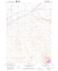
1950 Map of Rigby SE
USGS Topo · Published 1979About this map
Willow Creek carves a winding path through this Bonneville County landscape, where the intensive irrigation networks of the Snake River Plain meet the rising foothills. The map reveals an intricate system of water management including the South Branch Harrison Canal, Enterprise Canal, and Sidehill Ditch, reflecting the region's agricultural dependency. The northern half is dominated by rural family life and farming infrastructure, anchored by the Shelton Ward Church and Milo Cemetery. Transportation is defined by the Union Pacific rail line cutting across the plains toward the northeast. To the southeast, the terrain shifts significantly as the waters of Ririe Reservoir and Blacktail Cr enter the frame, while landmarks like Eagle Rock and the Milo Dry Farm mark the transition from irrigated valley to higher, drier elevations.
Find a feature on this map
18 named features on this map. Tap any name to fly to it.
Don’t see what you’re looking for? This feature index may not catch every label — zoom into the map to look around manually.
Map Details
Editions of this 1950 Rigby SE Map
2 editions found
Other maps of this area

1924 · Hell Creek
USGS Topo · 1:62,500

1924 · Ammon
USGS Topo · 1:62,500

1926 · Hell Creek
USGS Topo · 1:62,500

1948 · Rigby
USGS Topo · 1:24,000

1948 · Ucon
USGS Topo · 1:24,000

1949 · Ucon
USGS Topo · 1:24,000

1949 · Rigby
USGS Topo · 1:24,000

1950 · Ririe
USGS Topo · 1:24,000

1950 · Rigby
USGS Topo · 1:62,500

1950 · Rigby SE
USGS Topo · 1:24,000