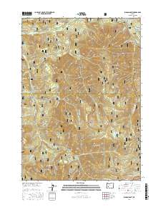
2017 Map of Rigdon Point
USGS Topo · Published 2017About this map
Rigdon Meadows serves as a prominent landmark in this upper reach of the Middle Fork Willamette River drainage. The terrain is defined by a dense network of forest development roads, such as Nat Forest Develop Road 2134 Rd, which snake through the Willamette National Forest to reach high points like McGowan Mtn and McLean Mtn. This 2017 survey details a landscape primarily managed for timber and recreation, where small water features like Lizard Lake and Indigo Springs provide critical points of interest among the steep drainages of Staley Cr and Tumblebug Cr. In the southern portion, the boundary between the Willamette and Umpqua National Forest follows the crest of the Calapooya Mountains, illustrating the complex management of Oregon's Cascade Range. The map also identifies distinctive geological formations like Lighthouse Rock and the aptly named Grassy Glade.
Find a feature on this map
60 named features on this map. Tap any name to fly to it.
Don’t see what you’re looking for? This feature index may not catch every label — zoom into the map to look around manually.
Map Details
Editions of this 2017 Rigdon Point Map
This is the sole edition of this map. No revisions or reprints were ever made.
Other maps of this area

1917 · Diamond Lake
USGS Topo · 1:125,000

1925 · Waldo Lake
USGS Topo · 1:125,000

1956 · Toketee Falls
USGS Topo · 1:62,500

1956 · Waldo Lake
USGS Topo · 1:62,500

1956 · Summit Lake
USGS Topo · 1:62,500

1956 · Oakridge
USGS Topo · 1:62,500

1958 · Roseburg
USGS Topo · 1:250,000

1959 · Roseburg
USGS Topo · 1:250,000

1978 · Diamond Lake
USGS Topo · 1:100,000

1983 · Oakridge
USGS Topo · 1:100,000