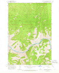
1964 Map of Riggins Hot Springs
USGS Topo · Published 1966About this map
The Salmon River carves a deep path through the Nezperce National Forest in this mid-1960s survey of Idaho’s interior. Centered on the geothermal waters of Riggins Hot Springs, the landscape is defined by its extreme vertical relief, stretching from the river banks at Music Bar up to high points like Berg Mountain and Van Ridge. Settlement is sparse, represented by isolated landmarks such as Hinkley Cabin and Long Cabin, which suggest the area's history of remote habitation and subsistence. A Lookout Tower on Chair Point and various prospects indicate a landscape managed for both resource extraction and fire protection. The intricate network of drainage systems, including Allison Creek and Partridge Creek, feeds into the Salmon, creating a complex series of ridges and canyons, most notably the steep walls of Box Canyon and the turbulent waters at Ruby Rapids.
Find a feature on this map
33 named features on this map. Tap any name to fly to it.
Don’t see what you’re looking for? This feature index may not catch every label — zoom into the map to look around manually.
Map Details
Editions of this 1964 Riggins Hot Springs Map
2 editions found
Other maps of this area

1938 · Riggins
USGS Topo · 1:96,000

1945 · Riggins
USGS Topo · 1:125,000

1955 · Grangeville
USGS Topo · 1:250,000

1959 · Grangeville
USGS Topo · 1:250,000

1963 · John Day Mtn
USGS Topo · 1:24,000

1963 · Lucile
USGS Topo · 1:24,000

1963 · Hershey Point
USGS Topo · 1:24,000
1963 · Florence
USGS Topo · 1:24,000
1964 · Patrick Butte
USGS Topo · 1:24,000

1964 · Riggins
USGS Topo · 1:24,000