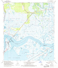
1968 Map of Rigolets
USGS Topo · Published 1969About this map
Fort Pike State Monument stands as a sentinel at the edge of the Rigolets, where the waters of Lake Pontchartrain meet the intricate marshlands of St. Tammany Parish. This landscape is defined by its labyrinthine waterways and islands, including Deer Island, Honey Island, and Weems Island. The transition from the dense Fritchie Marsh to the tidal passes of St. Catherine Pass and Hospital Pass reveals the complex hydrology of the Mississippi River Delta's eastern reaches.
Find a feature on this map
83 named features on this map. Tap any name to fly to it.
Don’t see what you’re looking for? This feature index may not catch every label — zoom into the map to look around manually.
Map Details
Editions of this 1968 Rigolets Map
4 editions found
Other maps of this area

1892 · Chef Menteur
USGS Topo · 1:62,500

1893 · Rigolets
USGS Topo · 1:62,500

1914 · Nicholson
USGS Topo · 1:62,500

1921 · Nicholson
USGS Topo · 1:62,500

1935 · Slidell
USGS Topo · 1:62,500

1935 · English Lookout
USGS Topo · 1:31,680

1936 · North Shore
USGS Topo · 1:31,680

1936 · Chef Menteur
USGS Topo · 1:62,500

1936 · Rigolets
USGS Topo · 1:62,500

1937 · Chef Menteur
USGS Topo · 1:31,680