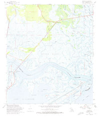
1968 Map of Rigolets
USGS Topo · Published 1974About this map
The Fort Pike State Monument stands as a sentinel at the narrow pass between Lake Pontchartrain and Lake Borgne, marking a landscape defined by intricate waterways and marshlands during the late 1960s. This survey illustrates the complex transition between the Pearl River delta and the coastal estuaries of the Rigolets. The settlement of White Kitchen and the nearby Ridge Memorial Ch sit atop Apple Pie Ridge, which provides a rare point of elevation amidst the vast expanse of the Fritchie Marsh. The map details the vital transportation corridor formed by the Louisville and Nashville Railroad and U.S. Route 90, crossing through Honey Island and over the Pike Bridge. For local historians, the inclusion of named locations like Grand Cop Point and Tanner Mill Pond offers a specific view of this coastal environment before modern development further altered the Louisiana shoreline.
Find a feature on this map
77 named features on this map. Tap any name to fly to it.
Don’t see what you’re looking for? This feature index may not catch every label — zoom into the map to look around manually.
Map Details
Editions of this 1968 Rigolets Map
4 editions found
Other maps of this area

1892 · Chef Menteur
USGS Topo · 1:62,500

1893 · Rigolets
USGS Topo · 1:62,500

1914 · Nicholson
USGS Topo · 1:62,500

1921 · Nicholson
USGS Topo · 1:62,500

1935 · Slidell
USGS Topo · 1:62,500

1935 · English Lookout
USGS Topo · 1:31,680

1936 · North Shore
USGS Topo · 1:31,680

1936 · Chef Menteur
USGS Topo · 1:62,500

1936 · Rigolets
USGS Topo · 1:62,500

1937 · Chef Menteur
USGS Topo · 1:31,680