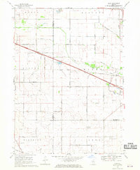
1968 Map of Riley
USGS Topo · Published 1970About this map
Coon Creek and Spring Creek meander through a fertile agricultural landscape at the intersection of Boone, McHenry, and De Kalb counties. The area is defined by a dense grid of family-named roads such as Fruit Farm Road, Carlson Road, and Engelsen Road, indicating a long-established rural community organized around local landmarks like the Grange Hall and the No 10 School.
Find a feature on this map
39 named features on this map. Tap any name to fly to it.
Don’t see what you’re looking for? This feature index may not catch every label — zoom into the map to look around manually.
Map Details
Editions of this 1968 Riley Map
2 editions found
Other maps of this area

1918 · Belvidere
USGS Topo · 1:62,500

1918 · Kirkland
USGS Topo · 1:62,500

1932 · Harvard
USGS Topo · 1:48,000

1937 · Harvard
USGS Topo · 1:62,500

1938 · Genoa
USGS Topo · 1:62,500

1944 · Belvidere
USGS Topo · 1:62,500

1954 · Rockford
USGS Topo · 1:250,000

1955 · Rockford
USGS Topo · 1:250,000

1958 · Rockford
USGS Topo · 1:250,000

1963 · Rockford
USGS Topo · 1:250,000