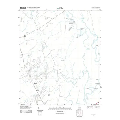
2011 Map of Rincon
USGS Topo · Published 2011About this map
Rincon serves as a central hub for Effingham County in this early 21st-century record, where residential expansion meets the winding wetlands of the Savannah River. The map reveals a landscape defined by its riparian geometry, with named landings like Newington Landing and Symons Landing marking historic access points to the river's eastern edge. A high concentration of family and community burial grounds, including the Gnann Cemetery, Rahn Cemetery, and Jones Cemetery, provides critical evidence for genealogists and local historians tracing the settlement patterns of this coastal Georgia region. The transition from established neighborhoods in the south, such as Silverwood Plantation and Goshen Villa, to the northern reaches near Birds illustrates the persistent balance between modern development and the natural drainage of Ebenezer Creek and Sweigoffer Creek. Point-of-land features such as Big Kiffer Point and Lady Washington Point further delineate the river's intricate path.
Find a feature on this map
111 named features on this map. Tap any name to fly to it.
Don’t see what you’re looking for? This feature index may not catch every label — zoom into the map to look around manually.
Map Details
Editions of this 2011 Rincon Map
This is the sole edition of this map. No revisions or reprints were ever made.
Other maps of this area

1919 · Egypt
USGS Topo · 1:62,500

1920 · Hardeeville
USGS Topo · 1:62,500

1920 · Meldrim
USGS Topo · 1:62,500

1939 · Egypt
USGS Topo · 1:62,500

1942 · Meldrim
USGS Topo · 1:62,500

1942 · Savannah
USGS Topo · 1:62,500

1943 · Hardeeville
USGS Topo · 1:62,500

1943 · Egypt
USGS Topo · 1:62,500

1947 · Savannah
USGS Topo · 1:250,000

1948 · Savannah
USGS Topo · 1:250,000