1950 Map of Rincon NE
USGS Topo · Published 1950About this map
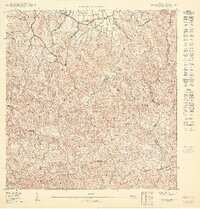
Piedras Blancas and Mal Paso anchor this 1950 survey of the terrain east of Rincón, where the Río Culebrinas winds through a landscape of sharp ridges and deep creek valleys. The settlement pattern reflects a rural society organized around local landmarks and faith, with the Capilla Malpaso and Capilla La Virgen del Buen Consejo serving as communal focal points. Education is represented by the Escuela Malpaso and the larger Escuela Segunda Unidad de Guanábano in the northern sector.
Find a feature on this map
24 named features on this map. Tap any name to fly to it.
Don’t see what you’re looking for? This feature index may not catch every label — zoom into the map to look around manually.
Map Details
Editions of this 1950 Rincon NE Map
This is the sole edition of this map. No revisions or reprints were ever made.
Other maps of this area

1937 · Aguadilla
USGS Topo · 1:20,000

1937 · Moca
USGS Topo · 1:20,000

1938 · Alto Sano
USGS Topo · 1:20,000

1941 · Moca
USGS Topo · 1:30,000

1941 · Rincon
USGS Topo · 1:30,000

1941 · Rincon
USGS Topo · 1:30,000

1942 · Moca
USGS Topo · 1:30,000

1942 · Central La Plata
USGS Topo · 1:30,000

1942 · Aguadilla
USGS Topo · 1:30,000

1946 · Ciales
USGS Topo · 1:30,000
Featured Places
- Sector Beníquez, Aguada
- Sector García, Aguada
- Sector Luis Bones, Aguada
- Sector Pilar Figueroa, Aguada
- Sector Rubí, Aguada