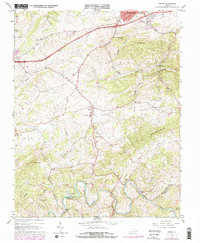
1965 Map of Riner
USGS Topo · Published 1978About this map
Pilot Mountain and the winding course of the Little River define the topography of this Southwest Virginia landscape at the junction of Montgomery and Floyd counties. The central community of Riner is a focal point for the region, anchored by the Alburn High Sch and surrounded by a network of rural churches and cemeteries that trace the area's genealogical roots, including Grace Ch, Edgemont Ch, and the Sunset Cem. In the north, the encroachment of modern infrastructure is evident near Christiansburg where Interstate 81 and the Norfolk and Western RR slice through the terrain. Cultural landmarks like Camp Carysbrook and the interestingly named Poorhouse Knob highlight the local history of recreation and social services in the mid-20th century, while the rugged elevation of Calfee Knob overlooks the numerous creeks feeding the river system.
Find a feature on this map
43 named features on this map. Tap any name to fly to it.
Don’t see what you’re looking for? This feature index may not catch every label — zoom into the map to look around manually.
Map Details
Editions of this 1965 Riner Map
3 editions found
Other maps of this area

1889 · Hillsville
USGS Topo · 1:125,000

1890 · Dublin
USGS Topo · 1:125,000

1890 · Christiansburg
USGS Topo · 1:125,000

1891 · Dublin
USGS Topo · 1:125,000

1892 · Hillsville
USGS Topo · 1:125,000

1896 · Hillsville
USGS Topo · 1:125,000

1932 · Blacksburg
USGS Topo · 1:48,000

1937 · Blacksburg
USGS Topo · 1:62,500

1950 · Radford
USGS Topo · 1:62,500

1953 · Winston-Salem
USGS Topo · 1:250,000