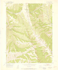
1952 Map of Rio Blanco
USGS Topo · Published 1954About this map
The Naval Oil Shale Reserve dominates the southern landscape of this 1952 survey, illustrating the strategic importance of energy resources in the post-war era along the border of Rio Blanco and Garfield counties. The topography is defined by the striking ridge of the Grand Hogback and the steep escarpments of the Book Cliffs, creating a drainage network for Piceance Creek and its many tributaries like Trapper Creek and Bitter Creek. A sense of shifting utility is evident in the presence of the Rio Blanco School (Aband) and the Rio Blanco Mine (Inactive), suggesting a rural community in transition as earlier settlements and extraction sites were being consolidated or left behind. The inclusion of a Ski Tow near the Government Road points to early recreational developments on the high slopes near Monument Peak.
Find a feature on this map
23 named features on this map. Tap any name to fly to it.
Don’t see what you’re looking for? This feature index may not catch every label — zoom into the map to look around manually.
Map Details
Editions of this 1952 Rio Blanco Map
5 editions found
Other maps of this area

1906 · Grand Hogback
USGS Topo · 1:125,000

1910 · Grand Hogback
USGS Topo · 1:125,000

1925 · Parachute Creek
USGS Topo · 1:62,500

1927 · Parachute Creek
USGS Topo · 1:62,500

1952 · Rio Blanco
USGS Topo · 1:24,000

1952 · Anvil Points
USGS Topo · 1:24,000

1952 · Horse Mountain
USGS Topo · 1:24,000

1952 · Rifle
USGS Topo · 1:24,000

1952 · No Name Ridge
USGS Topo · 1:24,000

1956 · Grand Junction
USGS Topo · 1:250,000