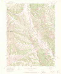
1952 Map of Rio Blanco
USGS Topo · Published 1972About this map
Rio Blanco sits at the northern edge of this high-altitude landscape, where the confluence of Piceance Creek and other smaller drainages shaped the early development of this portion of the Western Slope. The map highlights the significant intersection of natural geology and federal energy interests, dominated by the Naval Oil Shale Reserve. This vast administrative area is bordered by the dramatic formations of the Book Cliffs and the Grand Hogback, illustrating the difficult terrain that early settlers and surveyors navigated.
Find a feature on this map
18 named features on this map. Tap any name to fly to it.
Don’t see what you’re looking for? This feature index may not catch every label — zoom into the map to look around manually.
Map Details
Editions of this 1952 Rio Blanco Map
5 editions found
Other maps of this area

1906 · Grand Hogback
USGS Topo · 1:125,000

1910 · Grand Hogback
USGS Topo · 1:125,000

1925 · Parachute Creek
USGS Topo · 1:62,500

1927 · Parachute Creek
USGS Topo · 1:62,500

1952 · Rio Blanco
USGS Topo · 1:24,000

1952 · Anvil Points
USGS Topo · 1:24,000

1952 · Horse Mountain
USGS Topo · 1:24,000

1952 · Rifle
USGS Topo · 1:24,000

1952 · No Name Ridge
USGS Topo · 1:24,000

1956 · Grand Junction
USGS Topo · 1:250,000