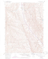
1952 Map of Rio Blanco
USGS Topo · Published 1984About this map
Rio Blanco School sits near the northern boundary of this western Colorado landscape, marking a localized center for the sparse settlement pattern along the high-country drainage. The map highlights the significant presence of the Naval Oil Shale Reserve, which dominates the southern portion of the quadrangle. This area reflects a mid-century period when industrial energy interests were firmly etched into the public land use of the region, evidenced by the Rio Blanco Mine (Inactive) located along the upper reaches of the drainage system.
Find a feature on this map
21 named features on this map. Tap any name to fly to it.
Don’t see what you’re looking for? This feature index may not catch every label — zoom into the map to look around manually.
Map Details
Editions of this 1952 Rio Blanco Map
5 editions found
Other maps of this area

1906 · Grand Hogback
USGS Topo · 1:125,000

1910 · Grand Hogback
USGS Topo · 1:125,000

1925 · Parachute Creek
USGS Topo · 1:62,500

1927 · Parachute Creek
USGS Topo · 1:62,500

1952 · Rio Blanco
USGS Topo · 1:24,000

1952 · Anvil Points
USGS Topo · 1:24,000

1952 · Horse Mountain
USGS Topo · 1:24,000

1952 · Rifle
USGS Topo · 1:24,000

1952 · No Name Ridge
USGS Topo · 1:24,000

1956 · Grand Junction
USGS Topo · 1:250,000