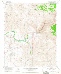
1954 Map of Rio Bravo Ranch
USGS Topo · Published 1967About this map
Rio Bravo Ranch sits at the heart of this mid-century landscape where the Kern River transitions from the steep canyons of the Sequoia National Forest into the valley floor. The geography here is defined by complex infrastructure designed to harness the river's descent, including the Kern River Aqueduct (Tunnel) and several powerhouses served by visible penstocks. Industrial activity is centered on the Ant Hill Oil Field and scattered gravel pits, reflecting the region's reliance on mineral extraction and energy production.
Find a feature on this map
16 named features on this map. Tap any name to fly to it.
Don’t see what you’re looking for? This feature index may not catch every label — zoom into the map to look around manually.
Map Details
Editions of this 1954 Rio Bravo Ranch Map
4 editions found
Other maps of this area

1906 · Bakersfield
USGS Topo · 1:62,500

1914 · Caliente
USGS Topo · 1:125,000

1920 · Delonagha
USGS Topo · 1:62,500

1926 · Glennville
USGS Topo · 1:62,500

1929 · Bena
USGS Topo · 1:31,680

1929 · Fairfax School
USGS Topo · 1:31,680

1931 · Edison
USGS Topo · 1:31,680

1932 · Bena
USGS Topo · 1:31,680

1932 · Fairfax School
USGS Topo · 1:31,680

1932 · Woody
USGS Topo · 1:62,500