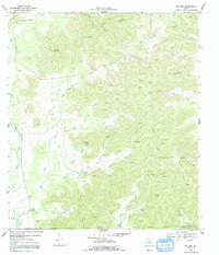
1969 Map of Rio Frio
USGS Topo · Published 1991About this map
Rio Frio serves as the primary focal point in this 1969 field-checked landscape where the Real and Uvalde County line traverses a complex network of canyons and creek beds. The drainage patterns of the Frio River and its various forks, including the East Frio River and Little Dry Frio Creek, reveal a terrain shaped by water, dotted with landmarks like Meridian Mountain and Hoover.
Find a feature on this map
41 named features on this map. Tap any name to fly to it.
Don’t see what you’re looking for? This feature index may not catch every label — zoom into the map to look around manually.
Map Details
Editions of this 1969 Rio Frio Map
2 editions found
Other maps of this area

1954 · San Antonio
USGS Topo · 1:250,000

1956 · Utopia
USGS Topo · 1:62,500

1957 · San Antonio
USGS Topo · 1:250,000

1957 · York Hollow
USGS Topo · 1:62,500

1960 · Magers Crossing
USGS Topo · 1:24,000

1964 · Circle Bluff
USGS Topo · 1:24,000

1964 · Sabinal Canyon
USGS Topo · 1:24,000
1969 · Vanderpool
USGS Topo · 1:24,000
1969 · Utopia
USGS Topo · 1:24,000
1969 · Rio Frio
USGS Topo · 1:24,000