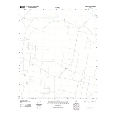
2010 Map of Rio Pecos Ranch
USGS Topo · Published 2010About this map
The Pecos River carves the northern boundary of this West Texas landscape, where the Imperial Ditch parallels its course to manage water in an arid environment. This 2010 survey of Pecos County illustrates a region defined by industrial extraction and ranching infrastructure. The Waha Oil Field occupies a central position, surrounded by a grid of ranch roads and specialized routes such as Dump Ground Rd and Trailer House Rd.
Find a feature on this map
14 named features on this map. Tap any name to fly to it.
Don’t see what you’re looking for? This feature index may not catch every label — zoom into the map to look around manually.
Map Details
Editions of this 2010 Rio Pecos Ranch Map
This is the sole edition of this map. No revisions or reprints were ever made.
Other maps of this area

1931 · Barstow
USGS Topo · 1:125,000

1954 · Pecos
USGS Topo · 1:250,000

1957 · Pecos
USGS Topo · 1:250,000

1963 · Ligon Ranch
USGS Topo · 1:24,000

1963 · China Lake NE
USGS Topo · 1:24,000

1963 · Rio Pecos Ranch
USGS Topo · 1:24,000

1963 · China Lake
USGS Topo · 1:24,000

1969 · 7 L Ranch
USGS Topo · 1:24,000
1973 · Coyanosa NW
USGS Topo · 1:24,000
1974 · Coyanosa
USGS Topo · 1:24,000