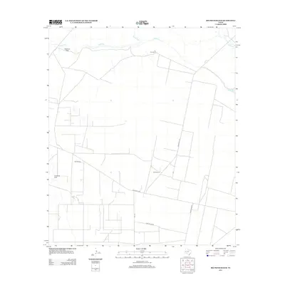
2013 Map of Rio Pecos Ranch
USGS Topo · Published 2013About this map
The Pecos River snakes through this arid West Texas landscape, defining the northern boundary of a region shaped by ranching and energy extraction. This 2013 survey of the Waha area captures a transition between traditional agriculture and modern industrial infrastructure. Local operations are anchored by the namesake Rio Pecos Ranch and landmarks like Twin Windmills, while the Waha Oil Field indicates the subsurface importance of the Permian Basin. Water management is a primary feature of the terrain, evidenced by the Imperial Ditch and natural drainage patterns like Hackberry Draw and Coyanosa Draw. A network of thoroughfares, including Ranch Road 1776 and Ranch Road 1450, connects these isolated outposts, illustrating the logistical layout required to maintain oil production and livestock in this environment.
Find a feature on this map
12 named features on this map. Tap any name to fly to it.
Don’t see what you’re looking for? This feature index may not catch every label — zoom into the map to look around manually.
Map Details
Editions of this 2013 Rio Pecos Ranch Map
This is the sole edition of this map. No revisions or reprints were ever made.
Other maps of this area

1931 · Barstow
USGS Topo · 1:125,000

1954 · Pecos
USGS Topo · 1:250,000

1957 · Pecos
USGS Topo · 1:250,000

1963 · Ligon Ranch
USGS Topo · 1:24,000

1963 · China Lake NE
USGS Topo · 1:24,000

1963 · Rio Pecos Ranch
USGS Topo · 1:24,000

1963 · China Lake
USGS Topo · 1:24,000

1969 · 7 L Ranch
USGS Topo · 1:24,000
1973 · Coyanosa NW
USGS Topo · 1:24,000
1974 · Coyanosa
USGS Topo · 1:24,000