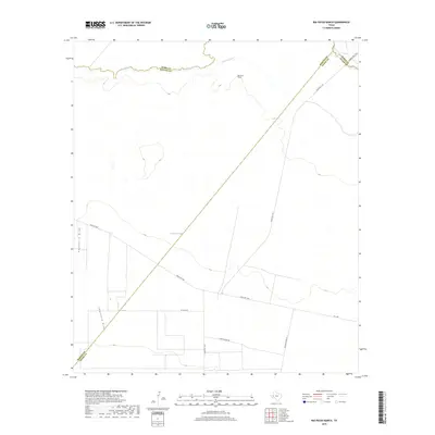
2019 Map of Rio Pecos Ranch
USGS Topo · Published 2019About this map
Pecos River serves as the primary boundary line between Ward, Reeves, and Pecos counties in this arid West Texas landscape. The northern reaches of the map show the Imperial Ditch running parallel to the river's winding course, indicating the vital role of irrigation in a region defined by its desert hydrology. Named for the ranching operations that anchor the area, Rio Pecos Ranch sits amidst a network of utility and local access roads, including the descriptively named Trailer House Rd and Dump Ground Rd. The terrain is shaped by significant drainage features such as Coyanosa Draw and Hackberry Draw, which intersect the flat reaches of the Trans-Pecos. These geographic markers, alongside long-standing routes like El Paso Rd, provide a window into the sparse but functional infrastructure of modern-day ranching and land management near the tri-county corner.
Find a feature on this map
15 named features on this map. Tap any name to fly to it.
Don’t see what you’re looking for? This feature index may not catch every label — zoom into the map to look around manually.
Map Details
Editions of this 2019 Rio Pecos Ranch Map
This is the sole edition of this map. No revisions or reprints were ever made.
Other maps of this area

1931 · Barstow
USGS Topo · 1:125,000

1954 · Pecos
USGS Topo · 1:250,000

1957 · Pecos
USGS Topo · 1:250,000

1963 · Ligon Ranch
USGS Topo · 1:24,000

1963 · China Lake NE
USGS Topo · 1:24,000

1963 · Rio Pecos Ranch
USGS Topo · 1:24,000

1963 · China Lake
USGS Topo · 1:24,000

1969 · 7 L Ranch
USGS Topo · 1:24,000
1973 · Coyanosa NW
USGS Topo · 1:24,000
1974 · Coyanosa
USGS Topo · 1:24,000