
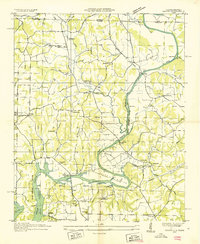
1936 Map of Ripley
USGS Topo · Published 1936About this map
Wheeler Reservoir dominates the northwestern corner of this study, reflecting the significant landscape transformations brought by the Tennessee Valley Authority. This advance sheet shows the reservoir boundary at 556 feet elevation, submerging the banks where Elk River Mills Bridge once stood. The surrounding Limestone County terrain is defined by a dense network of rural infrastructure, including many family-named landmarks and community hubs like Peeks Store, Tillmans Mill, and Lapingtons Store.
Find a feature on this map
55 named features on this map. Tap any name to fly to it.
Don’t see what you’re looking for? This feature index may not catch every label — zoom into the map to look around manually.
Map Details
Editions of this 1936 Ripley Map
This is the sole edition of this map. No revisions or reprints were ever made.
Other maps of this area

1888 · Huntsville
USGS Topo · 1:125,000

1892 · Huntsville
USGS Topo · 1:125,000

1935 · Athens
USGS Topo · 1:24,000

1936 · Union Hill
USGS Topo · 1:24,000

1936 · Stewart Cross Roads
USGS Topo · 1:24,000

1936 · Elkmont
USGS Topo · 1:24,000

1936 · Hillsboro
USGS Topo · 1:24,000

1936 · Tanner
USGS Topo · 1:24,000

1936 · Cairo
USGS Topo · 1:24,000
1936 · Salem
USGS Topo · 1:24,000