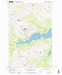
1968 Map of Rising Sun
USGS Topo · Published 1979About this map
Saint Mary Lake dominates this 1968 field-checked landscape, serving as the central basin for numerous glacial meltwater systems. The high-altitude terrain is defined by the winding Going To The Sun Road, which provides access to the Rising Sun settlement and various recreational points like the Sunrift Gorge. The map documents a complex network of backcountry infrastructure, including the Patrol Cabin near Lost Lake and various trail systems such as the Siyeh Pass Trail and Water Ouzel Trail.
Find a feature on this map
47 named features on this map. Tap any name to fly to it.
Don’t see what you’re looking for? This feature index may not catch every label — zoom into the map to look around manually.
Map Details
Editions of this 1968 Rising Sun Map
2 editions found
Other maps of this area

1901 · Browning
USGS Topo · 1:125,000

1903 · Browning
USGS Topo · 1:125,000

1904 · Chief Mountain
USGS Topo · 1:125,000

1938 · Chief Mountain
USGS Topo · 1:125,000

1960 · Cut Bank
USGS Topo · 1:250,000

1963 · Cut Bank
USGS Topo · 1:250,000

1964 · Cut Bank
USGS Topo · 1:250,000

1968 · Saint Mary
USGS Topo · 1:24,000

1968 · Babb
USGS Topo · 1:24,000
1968 · Cut Bank Pass
USGS Topo · 1:24,000