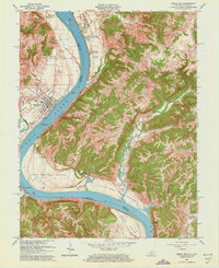
1961 Map of Rising Sun
USGS Topo · Published 1973About this map
The Ohio River carves a winding path through this 1961 survey, separating the riverfront city of Rising Sun in Indiana from the Kentucky hillsides. This stretch of the river valley is defined by significant alluvial plains, including the Upper East Bend Bottom and Mexico Bottom, where farming and small settlements have long thrived. The Kentucky side is particularly dense with genealogical markers, featuring numerous family burial grounds such as the Rice Cem and Stephens Cem tucked into the drainages of Gunpowder Creek and Middle Creek.
Find a feature on this map
54 named features on this map. Tap any name to fly to it.
Don’t see what you’re looking for? This feature index may not catch every label — zoom into the map to look around manually.
Map Details
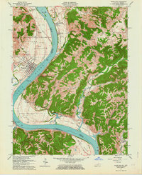
Editions of this 1961 Rising Sun Map
2 editions found
Other maps of this area

1914 · West Cincinnati
USGS Topo · 1:62,500

1915 · Lawrenceburg
USGS Topo · 1:48,000

1928 · Lawrenceburg
USGS Topo · 1:62,500

1932 · Lawrenceburg
USGS Topo · 1:62,500

1943 · Florence
USGS Topo · 1:24,000

1943 · Aberdeen
USGS Topo · 1:24,000

1943 · Aurora
USGS Topo · 1:24,000

1943 · Rising Sun
USGS Topo · 1:24,000

1943 · Lawrenceburg
USGS Topo · 1:24,000

1943 · Patriot
USGS Topo · 1:24,000