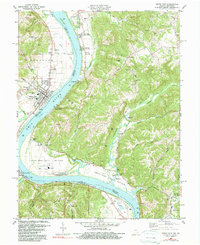
1981 Map of Rising Sun
USGS Topo · Published 1984About this map
The Ohio River separates Indiana and Kentucky as it winds past the established riverfront town of Rising Sun, where the Rising Sun County Middle Sch and Rising Sun Cem serve the local community. Across the water in Kentucky, the map documents a series of rural hamlets including Rabbit Hash and Belleview (Grant PO), the latter retaining its historical post office designation. The landscape is defined by the sharp contrast between the wide agricultural flats of Upper East Bend Bottom and the steep, wooded hillsides of Bogus Ridge and Randolph.
Find a feature on this map
85 named features on this map. Tap any name to fly to it.
Don’t see what you’re looking for? This feature index may not catch every label — zoom into the map to look around manually.
Map Details
Editions of this 1981 Rising Sun Map
Other maps of this area

1914 · West Cincinnati
USGS Topo · 1:62,500

1915 · Lawrenceburg
USGS Topo · 1:48,000

1928 · Lawrenceburg
USGS Topo · 1:62,500

1932 · Lawrenceburg
USGS Topo · 1:62,500

1943 · Florence
USGS Topo · 1:24,000

1943 · Aberdeen
USGS Topo · 1:24,000

1943 · Aurora
USGS Topo · 1:24,000

1943 · Rising Sun
USGS Topo · 1:24,000

1943 · Lawrenceburg
USGS Topo · 1:24,000

1943 · Patriot
USGS Topo · 1:24,000