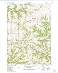
1983 Map of Rising Sun
USGS Topo · Published 1983About this map
The rolling Driftless Area along the Vernon and Crawford County line is defined here by a series of narrow ridges and deep hollows. Small agricultural settlements like Rising Sun, Liberty Pole, and Fargo are situated along the high ground, connected by a network of winding roads such as Dolan Road and Traastad Road. The landscape is etched with complex drainage systems including Hornby Hollow and Tainter Creek, while landmarks like Monument Rock and Nash Ridge provide distinctive navigational points. Local life is centered around community hubs like St James Ch and the Center Sch near Liberty Pole. This 1980s-era survey captures a rural Wisconsin landscape where topography dictates the patterns of settlement and travel, showing numerous small family-named ridges like Lathan Ridge and McManus Ridge.
Find a feature on this map
47 named features on this map. Tap any name to fly to it.
Don’t see what you’re looking for? This feature index may not catch every label — zoom into the map to look around manually.
Map Details
Editions of this 1983 Rising Sun Map
This is the sole edition of this map. No revisions or reprints were ever made.
Other maps of this area

1903 · Waukon
USGS Topo · 1:125,000

1923 · Viroqua
USGS Topo · 1:62,500

1924 · Gays Mills
USGS Topo · 1:62,500

1926 · Gays Mills
USGS Topo · 1:62,500

1926 · Stoddard
USGS Topo · 1:62,500

1926 · Viroqua
USGS Topo · 1:62,500

1929 · Ferryville
USGS Topo · 1:62,500

1932 · Ferryville
USGS Topo · 1:62,500

1958 · La Crosse
USGS Topo · 1:250,000

1961 · La Crosse
USGS Topo · 1:250,000