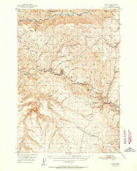
1952 Map of Ritter
USGS Topo · Published 1952About this map
The Middle Fork John Day River carves through this northern Grant County landscape, serving as a focal point for settlement and industry in the early 1950s. The community of Ritter stands near the center of the sheet, defined by the presence of Ritter Hot Springs and a Gaging Station on the riverbank. Local education and community life are marked by the Threemile School, Ritter Sch, and Range School, while the Ritter Cemetery provides a primary reference for genealogical research in the area. Evidence of the timber economy is visible at the Lumber Mill located near West Fork Meadow Brook. The terrain transitions from the high elevations of the Umatilla National Forest and Meadow Brook Summit down into the complex drainage systems of Twelvemile Creek and Long Creek. Notable landmarks such as Sugar Loaf Mtn and Ritter Butte overlook the narrow basins and gulches that dictated the placement of early mountain roads and the Eightmile Trail.
Find a feature on this map
70 named features on this map. Tap any name to fly to it.
Don’t see what you’re looking for? This feature index may not catch every label — zoom into the map to look around manually.
Map Details
Editions of this 1952 Ritter Map
2 editions found
Other maps of this area

1949 · Long Creek
USGS Topo · 1:62,500

1949 · Susanville
USGS Topo · 1:62,500

1950 · Ritter
USGS Topo · 1:62,500

1951 · Susanville
USGS Topo · 1:62,500

1951 · Long Creek
USGS Topo · 1:62,500

1951 · Courtrock
USGS Topo · 1:62,500

1951 · Monument
USGS Topo · 1:62,500

1951 · Dale
USGS Topo · 1:62,500

1952 · Ritter
USGS Topo · 1:62,500

1953 · Pendleton
USGS Topo · 1:250,000