
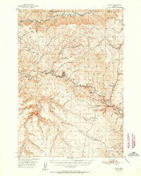
1952 Map of Ritter
USGS Topo · Published 1952About this map
Ritter serves as the central hub of this 1952 topographic study, located at a sharp bend where the North Fork John Day River meets local creeks. The settlement’s social and infrastructure landscape is well-documented, featuring the Ritter Grange, Ritter Sch, and the Ritter Cemetery. A notable local landmark is the Ritter Hot Springs, situated near a Gaging Station on the riverbank.
Find a feature on this map
75 named features on this map. Tap any name to fly to it.
Don’t see what you’re looking for? This feature index may not catch every label — zoom into the map to look around manually.
Map Details
Editions of this 1952 Ritter Map
2 editions found
Other maps of this area

1949 · Long Creek
USGS Topo · 1:62,500

1949 · Susanville
USGS Topo · 1:62,500

1950 · Ritter
USGS Topo · 1:62,500

1951 · Susanville
USGS Topo · 1:62,500

1951 · Long Creek
USGS Topo · 1:62,500

1951 · Courtrock
USGS Topo · 1:62,500

1951 · Monument
USGS Topo · 1:62,500

1951 · Dale
USGS Topo · 1:62,500

1953 · Pendleton
USGS Topo · 1:250,000

1955 · Canyon City
USGS Topo · 1:250,000