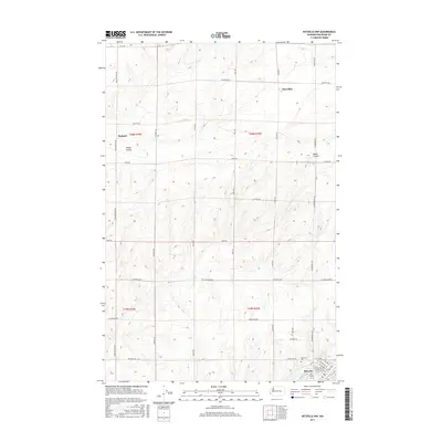
2017 Map of Ritzville NW
USGS Topo · Published 2017About this map
Ritzville serves as the focal point for this section of Adams County, where the street grid of the town’s northern edge meets a landscape dominated by agriculture and dryland coulees. The map illustrates a transition from the urban streets of N Division St and Main Ave to a vast network of section-line roads such as Tokio Rd and Marcellus Rd. Small outposts like Marcellus and Packard anchor the surrounding territory, connected by the distinctive terrain of Rocky Coulee and Bauer Coulee. Local history is centered around the Memorial Cem and Pru Field on the outskirts of the county seat. This survey captures a highly organized rural landscape defined by large-scale farming plots and family-named roads like Schoessler Rd and Neergaard Rd, reflecting the enduring agricultural heritage of the Palouse region in the early 21st century.
Find a feature on this map
41 named features on this map. Tap any name to fly to it.
Don’t see what you’re looking for? This feature index may not catch every label — zoom into the map to look around manually.
Map Details
Editions of this 2017 Ritzville NW Map
This is the sole edition of this map. No revisions or reprints were ever made.
Other maps of this area

1953 · Ritzville
USGS Topo · 1:250,000

1959 · Ritzville
USGS Topo · 1:250,000

1965 · Ritzville
USGS Topo · 1:250,000

1967 · Ritzville SW
USGS Topo · 1:24,000

1967 · Ritzville SE
USGS Topo · 1:24,000

1967 · Schoonover
USGS Topo · 1:24,000

1967 · Ritzville NE
USGS Topo · 1:24,000

1967 · Ritzville NW
USGS Topo · 1:24,000
1967 · Reiman SE
USGS Topo · 1:24,000

1968 · Sylvan Lake
USGS Topo · 1:24,000