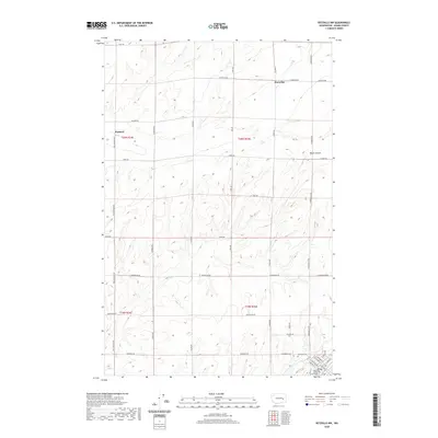
2020 Map of Ritzville NW
USGS Topo · Published 2020About this map
The small agricultural settlement of Marcellus and the outlying community of Packard define this area of Adams County, where the high plateau landscape is deeply etched by Bauer Coulee. This modern survey reveals a geometric grid of rural roads named for local families, including Bauer Rd, Dewald Rd, and Schoessler Rd, illustrating the enduring nature of land divisions in Washington's dryland wheat country. In the southeast corner, the outskirts of the county seat emerge, featuring the Adams County Courthouse and Memorial Cem. The layout of the streets, such as N Division St and E Main Ave, transitions from the broad expanses of the surrounding sections into the more concentrated development of the town. This map provides a clear view of the intersection between the region's historical agricultural roots and its modern administrative center.
Find a feature on this map
38 named features on this map. Tap any name to fly to it.
Don’t see what you’re looking for? This feature index may not catch every label — zoom into the map to look around manually.
Map Details
Editions of this 2020 Ritzville NW Map
This is the sole edition of this map. No revisions or reprints were ever made.
Other maps of this area

1953 · Ritzville
USGS Topo · 1:250,000

1959 · Ritzville
USGS Topo · 1:250,000

1965 · Ritzville
USGS Topo · 1:250,000

1967 · Ritzville SW
USGS Topo · 1:24,000

1967 · Ritzville SE
USGS Topo · 1:24,000

1967 · Schoonover
USGS Topo · 1:24,000

1967 · Ritzville NE
USGS Topo · 1:24,000

1967 · Ritzville NW
USGS Topo · 1:24,000
1967 · Reiman SE
USGS Topo · 1:24,000

1968 · Sylvan Lake
USGS Topo · 1:24,000