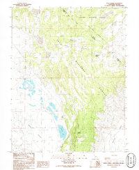
1986 Map of River Spring
USGS Topo · Published 1986About this map
Pizona serves as a remote focal point on this 1986 provisional survey, situated near the intersection of the Toiyabe National Forest and Inyo National Forest boundaries. The map highlights a complex network of hydrologic features along the California-Nevada state line, including the isolated waters of McNamara Lake and the extensive River Spring Lakes system. The geography is defined by the sharp transition between the Adobe Valley floor and the rising slopes of the Benton Range, where Antelope Mountain stands as a prominent landmark. This document details the essential water sources that supported activity in this arid high-desert corridor, from Antelope Spring to Upper Pizona Spring, while tracing the established Base Line and high-voltage Trans Line corridors that cross the desert floor.
Find a feature on this map
20 named features on this map. Tap any name to fly to it.
Don’t see what you’re looking for? This feature index may not catch every label — zoom into the map to look around manually.
Map Details
Editions of this 1986 River Spring Map
2 editions found
Other maps of this area

1909 · Hawthorne
USGS Topo · 1:250,000

1911 · Hawthorne
USGS Topo · 1:250,000

1914 · Mt. Morrison
USGS Topo · 1:125,000

1915 · Hawthorne
USGS Topo · 1:250,000

1917 · White Mountain
USGS Topo · 1:125,000

1947 · Mariposa
USGS Topo · 1:250,000

1948 · Walker Lake
USGS Topo · 1:250,000

1948 · Mariposa
USGS Topo · 1:250,000

1957 · Walker Lake
USGS Topo · 1:250,000

1957 · Mariposa
USGS Topo · 1:250,000