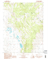
1986 Map of River Spring
USGS Topo · Published 1986About this map
Adobe Valley and the high desert basins of Mono County dominate this mid-1980s landscape at the boundary between Inyo National Forest and Toiyabe National Forest. The terrain is defined by its water sources, which were critical for the small settlement at Pizona and the surrounding livestock and transit routes. The map records a series of vital springs and catchments, including River Spring, Upper Pizona Spring, and Antelope Spring, which feed into local basins like River Spring Lakes and Antelope Lake.
Find a feature on this map
20 named features on this map. Tap any name to fly to it.
Don’t see what you’re looking for? This feature index may not catch every label — zoom into the map to look around manually.
Map Details
Editions of this 1986 River Spring Map
2 editions found
Other maps of this area

1909 · Hawthorne
USGS Topo · 1:250,000

1911 · Hawthorne
USGS Topo · 1:250,000

1914 · Mt. Morrison
USGS Topo · 1:125,000

1915 · Hawthorne
USGS Topo · 1:250,000

1917 · White Mountain
USGS Topo · 1:125,000

1947 · Mariposa
USGS Topo · 1:250,000

1948 · Walker Lake
USGS Topo · 1:250,000

1948 · Mariposa
USGS Topo · 1:250,000

1957 · Walker Lake
USGS Topo · 1:250,000

1957 · Mariposa
USGS Topo · 1:250,000