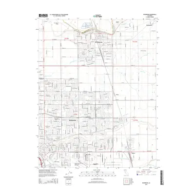
2015 Map of Riverbank
USGS Topo · Published 2015About this map
The Stanislaus River and Tuolumne River anchor this portion of the San Joaquin Valley, defining a landscape where intensive agriculture meets expanding residential development. The city of Riverbank occupies a strategic bend in the river, while the northern reaches of Modesto show a dense grid of suburban expansion toward E Briggsmore Ave and Sylvan Ave. This 2015 perspective highlights the critical role of water management in the Central Valley, evidenced by a complex network of irrigation infrastructure including the Moulton Lateral, Dixon Lateral, and Lateral Number One. Transportation and logistics remain central to the region's character, marked by the intersection of the BNSF Railway and Sierra RR, as well as the presence of the Modesto City-County Airport-Harry Sham Field and the private Peterson Airport. Local institutions like Saint Stanislaus Cemetery and the Galen Coll of Medical and Dental Assistants anchor the community's social fabric amidst these sprawling transit and water corridors.
Find a feature on this map
58 named features on this map. Tap any name to fly to it.
Don’t see what you’re looking for? This feature index may not catch every label — zoom into the map to look around manually.
Map Details
Editions of this 2015 Riverbank Map
This is the sole edition of this map. No revisions or reprints were ever made.
Other maps of this area

1914 · Avena
USGS Topo · 1:31,680

1915 · Oakdale
USGS Topo · 1:31,680

1915 · Westport
USGS Topo · 1:31,680

1915 · Salida
USGS Topo · 1:31,680

1915 · Thalheim
USGS Topo · 1:31,680

1916 · Riverbank
USGS Topo · 1:31,680

1916 · Denair
USGS Topo · 1:31,680

1916 · Waterford
USGS Topo · 1:31,680

1916 · Ceres
USGS Topo · 1:31,680

1939 · Modesto East
USGS Topo · 1:62,500