
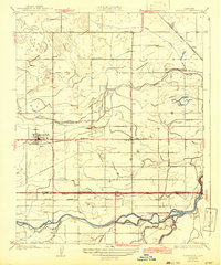
1927 Map of Riverdale
USGS Topo · Published 1927About this map
The Kings River and its intricate network of waterways, including Murphy Slough and Fresno Slough, dominate this 1920s landscape on the border of Fresno and Kings Counties. The town of Riverdale serves as a primary hub, while smaller rail-side settlements like Camden, Clint, and Hub mark the paths of the Southern Pacific and the Atchison Topeka and Santa Fe railroads.
Find a feature on this map
31 named features on this map. Tap any name to fly to it.
Don’t see what you’re looking for? This feature index may not catch every label — zoom into the map to look around manually.
Map Details
Editions of this 1927 Riverdale Map
2 editions found
Other maps of this area

1924 · Riverdale
USGS Topo · 1:31,680

1924 · Conejo
USGS Topo · 1:31,680

1925 · Raisin
USGS Topo · 1:31,680

1925 · Caruthers
USGS Topo · 1:31,680

1926 · Hanford
USGS Topo · 1:31,680

1926 · Lethent
USGS Topo · 1:31,680

1927 · Laton
USGS Topo · 1:31,680

1927 · Burrel
USGS Topo · 1:31,680

1927 · Lemoore
USGS Topo · 1:31,680
1946 · Selma
USGS Topo · 1:62,500