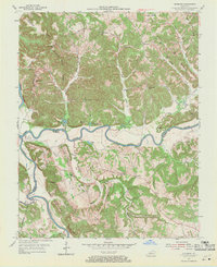
1954 Map of Riverside
USGS Topo · Published 1971About this map
The confluence of the Green River and Barren River defines this 1954 landscape, where the meandering waterways form a natural boundary between Butler and Warren counties. The terrain is characterized by a series of narrow ridges and hollows, such as Hogback Ridge and Lettered Rock Ridge, which forced early settlements like Jetson and Riverside into isolated clusters. Small family-named schools and churches served these rural communities, including Cedar Grove Sch and the Oak Forest Ch.
Find a feature on this map
57 named features on this map. Tap any name to fly to it.
Don’t see what you’re looking for? This feature index may not catch every label — zoom into the map to look around manually.
Map Details
Editions of this 1954 Riverside Map
3 editions found
Other maps of this area

1914 · Little Muddy
USGS Topo · 1:62,500

1922 · Leitchfield
USGS Topo · 1:48,000

1922 · Brownsville
USGS Topo · 1:62,500

1923 · Brownsville
USGS Topo · 1:62,500

1925 · Spring Lick
USGS Topo · 1:62,500

1925 · Leitchfield
USGS Topo · 1:62,500

1953 · Ready
USGS Topo · 1:24,000

1954 · Evansville
USGS Topo · 1:250,000

1954 · Bowling Green North
USGS Topo · 1:24,000

1954 · Welchs Creek
USGS Topo · 1:24,000