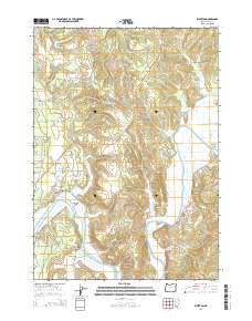
2014 Map of Riverton
USGS Topo · Published 2014About this map
The Coquille River winds through this coastal valley, anchoring a series of historic riverfront settlements including Riverton, Parkersburg, and Randolph. The landscape is a complex network of waterways, where the river meets Randolph Slough, Iowa Slough, and Hatchet Slough near the prominent Randolph Island. For genealogists and local historians, the presence of several family and community burial grounds, such as Randolph Cem, Kronenberg Cem, Hultin Cem, and Russell Cem, provides specific points of interest for tracing early families in Coos County. North of the river, Beaver Hill and the remnants of the Old Railroad Grade Rd reflect the area's industrial and transportation history. The proximity of features like Rocky Point and Caufield Gulch further highlights the varied topography where the tide-water lowlands meet the rising coastal hills.
Find a feature on this map
113 named features on this map. Tap any name to fly to it.
Don’t see what you’re looking for? This feature index may not catch every label — zoom into the map to look around manually.
Map Details
Editions of this 2014 Riverton Map
This is the sole edition of this map. No revisions or reprints were ever made.
Other maps of this area

1896 · Coos Bay
USGS Topo · 1:125,000

1898 · Coos Bay
USGS Topo · 1:125,000

1900 · Coos Bay
USGS Topo · 1:125,000

1942 · Empire
USGS Topo · 1:62,500

1942 · Coquille
USGS Topo · 1:62,500

1942 · Coos Bay
USGS Topo · 1:62,500

1943 · Bandon
USGS Topo · 1:62,500

1944 · Empire
USGS Topo · 1:62,500

1944 · Bandon
USGS Topo · 1:62,500

1945 · Coquille
USGS Topo · 1:62,500