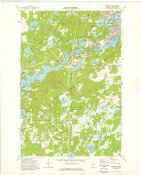
1973 Map of Riverton
USGS Topo · Published 1976About this map
Industrial activity and wetland conservation define this landscape along the Mississippi River. The village of Riverton serves as the focal point for a region heavily marked by the Cuyuna Iron Range's influence, with extensive operations visible at the Sagamore Mine, Virginia Mine, and Alstead Mine. These mining sites, often accompanied by a Tailings Pond, sit in close proximity to the numerous glacial lakes that characterize the area, including Little Menomin Lake and Blackhoof Lake.
Find a feature on this map
49 named features on this map. Tap any name to fly to it.
Don’t see what you’re looking for? This feature index may not catch every label — zoom into the map to look around manually.
Map Details
Editions of this 1973 Riverton Map
This is the sole edition of this map. No revisions or reprints were ever made.
Other maps of this area

1912 · Deerwood
USGS Topo · 1:62,500

1913 · Cuyuna
USGS Topo · 1:62,500

1914 · Deerwood
USGS Topo · 1:62,500

1915 · Cuyuna
USGS Topo · 1:62,500

1915 · Brainerd
USGS Topo · 1:62,500

1918 · Brainerd
USGS Topo · 1:62,500

1953 · Duluth
USGS Topo · 1:250,000

1953 · Brainerd
USGS Topo · 1:250,000

1957 · Brainerd
USGS Topo · 1:250,000

1958 · Brainerd
USGS Topo · 1:250,000