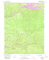
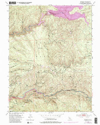
1950 Map of Riverton
USGS Topo · Published 1983About this map
The South Fork American River carves through the heart of the Eldorado National Forest, defining the rugged geography of this 1950 survey. Settlements like Riverton and White Hall serve as focal points along the river corridor, where the presence of a Sawmill and a Quarry suggests a local economy tied to timber and resource extraction. The landscape is marked by steep ridges such as Peavine Ridge and Government Ridge, and the development of the Union Valley Reservoir in the north indicates significant water management and infrastructure expansion during this era.
Find a feature on this map
52 named features on this map. Tap any name to fly to it.
Don’t see what you’re looking for? This feature index may not catch every label — zoom into the map to look around manually.
Map Details
Editions of this 1950 Riverton Map
6 editions found
Other maps of this area

1889 · Pyramid Peak
USGS Topo · 1:125,000

1891 · Placerville
USGS Topo · 1:125,000

1891 · Pyramid Peak
USGS Topo · 1:125,000

1892 · Placerville
USGS Topo · 1:125,000

1893 · Placerville
USGS Topo · 1:125,000

1895 · Pyramid Peak
USGS Topo · 1:125,000

1896 · Pyramid Peak
USGS Topo · 1:125,000

1947 · Sacramento
USGS Topo · 1:250,000

1948 · Sacramento
USGS Topo · 1:250,000

1950 · Riverton
USGS Topo · 1:24,000