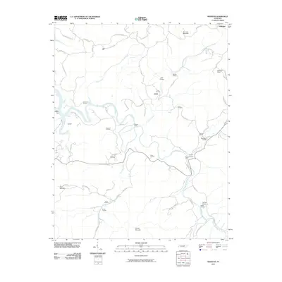
2010 Map of Riverton
USGS Topo · Published 2010About this map
The East Fork Obey River defines the landscape of this Fentress County region, winding through a series of hollows and ridges that separate small rural settlements. Family history is deeply rooted in the numerous burial grounds scattered across the terrain, including the Robbinstown Cemetery, Beatytown Cemetery, and the Storie Cemetery. Near the western edge of the map, the Eastport Dock sits along the river's path, marking a point of transition toward the larger waterway. The intricate network of local roads like Robbinstown Rd and Skinner Mountain Rd connects isolated landmarks such as Skinner Mountain and Goose Neck. This survey illustrates the persistent rural character of the area, where geographical features like Poplar Cove and Dark Hollow continue to dictate the placement of homes and small-scale infrastructure.
Find a feature on this map
68 named features on this map. Tap any name to fly to it.
Don’t see what you’re looking for? This feature index may not catch every label — zoom into the map to look around manually.
Map Details
Editions of this 2010 Riverton Map
This is the sole edition of this map. No revisions or reprints were ever made.
Other maps of this area

1895 · Wartburg
USGS Topo · 1:125,000

1896 · Wartburg
USGS Topo · 1:125,000

1897 · Standingstone
USGS Topo · 1:125,000

1898 · Standingstone
USGS Topo · 1:125,000

1929 · Byrdstown
USGS Topo · 1:62,500

1934 · Pall Mall
USGS Topo · 1:62,500

1954 · Crawford
USGS Topo · 1:24,000

1954 · Jamestown
USGS Topo · 1:24,000

1954 · Grimsley
USGS Topo · 1:24,000
1954 · Pall Mall
USGS Topo · 1:24,000