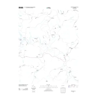
2013 Map of Riverton
USGS Topo · Published 2013About this map
E Fork Obey River winds through this section of the Cumberland Plateau, defining a landscape of deep hollows and high ridges in the years following the creation of Dale Hollow Lake. This 2013 survey illustrates a network of small, established rural communities such as Little Crab, Riverton, and Manson, connected by a winding system of local roads including Cricket Creek Rd and King Mountain Rd. The terrain is characterized by named elevations like Skinner Mountain and Double Top, interspersed with numerous hollows such as Dark Hollow and Taylor Hollow. The presence of Eastport Dock on the eastern edge of the reservoir suggests the importance of water-based recreation and access to the region. To the southeast, the settlements of Helena and Glenobey are situated near the headwaters of Poplar Cove Cr and Buffalo Cove Cr, highlighting the enduring pattern of valley-floor habitation in this part of Tennessee.
Find a feature on this map
88 named features on this map. Tap any name to fly to it.
Don’t see what you’re looking for? This feature index may not catch every label — zoom into the map to look around manually.
Map Details
Editions of this 2013 Riverton Map
This is the sole edition of this map. No revisions or reprints were ever made.
Other maps of this area

1895 · Wartburg
USGS Topo · 1:125,000

1896 · Wartburg
USGS Topo · 1:125,000

1897 · Standingstone
USGS Topo · 1:125,000

1898 · Standingstone
USGS Topo · 1:125,000

1929 · Byrdstown
USGS Topo · 1:62,500

1934 · Pall Mall
USGS Topo · 1:62,500

1954 · Crawford
USGS Topo · 1:24,000

1954 · Jamestown
USGS Topo · 1:24,000

1954 · Grimsley
USGS Topo · 1:24,000
1954 · Pall Mall
USGS Topo · 1:24,000