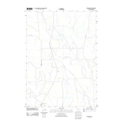
2012 Map of Riverview
USGS Topo · Published 2012About this map
The settlement of Riverview and the crossroads at Mule Creek Junction anchor this high-plains landscape in eastern Wyoming. This area of Niobrara County is defined by its complex drainage network, where numerous watercourses such as Robbers Roost Cr, Bobcat Cr, and Lone Tree Cr converge toward the larger Cheyenne River. The presence of the Campbell Number 1 Reservoir indicates the critical role of water management in this arid ranching territory. Transportation routes like Old US Hwy 85 and Cheyenne River Rd parallel the natural contours of the land, connecting these isolated outposts. Distinctive terrain features such as Sand Draw provide landmarks for local history researchers tracing the development of the region's cattle and oil industry infrastructure during the early 21st century.
Find a feature on this map
16 named features on this map. Tap any name to fly to it.
Don’t see what you’re looking for? This feature index may not catch every label — zoom into the map to look around manually.
Map Details
Editions of this 2012 Riverview Map
This is the sole edition of this map. No revisions or reprints were ever made.
Other maps of this area

1899 · Newcastle
USGS Topo · 1:125,000

1901 · Newcastle
USGS Topo · 1:125,000

1951 · Dewey
USGS Topo · 1:24,000

1951 · Dewey SW
USGS Topo · 1:24,000

1951 · Twentyone Divide
USGS Topo · 1:24,000

1955 · Newcastle
USGS Topo · 1:250,000

1958 · Newcastle
USGS Topo · 1:250,000

1978 · Riverview
USGS Topo · 1:24,000

1978 · Mule Creek
USGS Topo · 1:24,000
1978 · Mule Creek SE
USGS Topo · 1:24,000