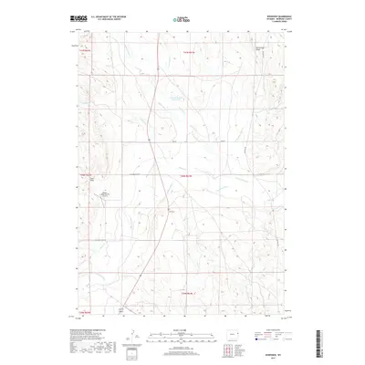
2017 Map of Riverview
USGS Topo · Published 2017About this map
The Cheyenne River winds through the heart of this high plains landscape in eastern Wyoming, where the settlement of Riverview serves as a central landmark. The area is defined by a dense network of seasonal drainages, including Robbers Roost Cr, Bobcat Cr, and Lone Tree Cr, which reveal the hydrological patterns of Niobrara County. Near the northern boundary, Rattlesnake Ridge provides a significant topographic elevation change, overlooking the Campbell Number 1 Reservoir. This 2017 survey documents the modern infrastructure of the ranching country, capturing the Robbers Roost Ranch Airport and the path of Old Hwy 85 alongside newer routes like Pipe Rd and Cheyenne River Rd. Smaller tributaries such as Alkali Cr and Mule Cr further illustrate the broken terrain and natural draws of this ranchland region.
Find a feature on this map
23 named features on this map. Tap any name to fly to it.
Don’t see what you’re looking for? This feature index may not catch every label — zoom into the map to look around manually.
Map Details
Editions of this 2017 Riverview Map
This is the sole edition of this map. No revisions or reprints were ever made.
Other maps of this area

1899 · Newcastle
USGS Topo · 1:125,000

1901 · Newcastle
USGS Topo · 1:125,000

1951 · Dewey
USGS Topo · 1:24,000

1951 · Dewey SW
USGS Topo · 1:24,000

1951 · Twentyone Divide
USGS Topo · 1:24,000

1955 · Newcastle
USGS Topo · 1:250,000

1958 · Newcastle
USGS Topo · 1:250,000

1978 · Riverview
USGS Topo · 1:24,000

1978 · Mule Creek
USGS Topo · 1:24,000
1978 · Mule Creek SE
USGS Topo · 1:24,000