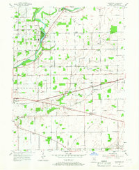
1953 Map of Riverwood
USGS Topo · Published 1967About this map
The White River flows prominently through the northwest corner of this Hamilton County landscape, anchoring settlements like Riverwood and Strawtown. In the mid-1950s, this area north of Indianapolis maintained a primarily rural character, defined by small crossroads communities and family-named landmarks. Institutional history is evident at the County Home in Noblesville township and the Consolidated Sch near Durbin. Local industry and infrastructure are reflected in the Power Sta and Gaging Sta along the river, while the New York Chicago and St Louis railroad cuts across the northern terrain. The cultural landscape is dotted with numerous country churches and burial grounds, including Victory Chapel, Zimmer Cem, and the Stony Creek Cem, offering a detailed view of the community's mid-century social and religious hubs.
Find a feature on this map
33 named features on this map. Tap any name to fly to it.
Don’t see what you’re looking for? This feature index may not catch every label — zoom into the map to look around manually.
Map Details
Editions of this 1953 Riverwood Map
2 editions found
Other maps of this area

1952 · Fishers
USGS Topo · 1:24,000

1952 · Ingalls
USGS Topo · 1:24,000

1952 · Mc Cordsville
USGS Topo · 1:24,000

1953 · Lapel
USGS Topo · 1:24,000

1953 · Riverwood
USGS Topo · 1:24,000

1953 · Noblesville
USGS Topo · 1:24,000

1953 · Cincinnati
USGS Topo · 1:250,000

1953 · Danville
USGS Topo · 1:250,000

1953 · Indianapolis
USGS Topo · 1:250,000

1953 · Muncie
USGS Topo · 1:250,000