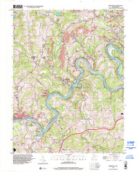
1997 Map of Rivesville
USGS Topo · Published 2002About this map
The Monongahela River winds through this West Virginia coal country, its course marked by industrial infrastructure including Hilderbrand Lock and Dam and Opekiska Lock and Dam. The landscape is heavily defined by extraction, with numerous labels for former mines scattered across the hills surrounding settlements like National, Everettsville, and Montana (Montana Mines PO). These mining towns are linked by historical transport corridors like the Old Indian Railroad and winding runs such as Stewart Run and Indian Creek.
Find a feature on this map
60 named features on this map. Tap any name to fly to it.
Don’t see what you’re looking for? This feature index may not catch every label — zoom into the map to look around manually.
Map Details
Editions of this 1997 Rivesville Map
This is the sole edition of this map. No revisions or reprints were ever made.
Other maps of this area

1886 · St. George
USGS Topo · 1:125,000

1891 · St. George
USGS Topo · 1:125,000

1902 · Fairmont
USGS Topo · 1:62,500

1902 · Morgantown
USGS Topo · 1:62,500

1904 · Blacksville
USGS Topo · 1:62,500

1907 · Thornton
USGS Topo · 1:62,500

1923 · Blacksville
USGS Topo · 1:62,500

1923 · Fairmont
USGS Topo · 1:62,500

1925 · Blacksville
USGS Topo · 1:62,500

1925 · Morgantown
USGS Topo · 1:62,500