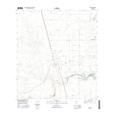
2016 Map of Riviera
USGS Topo · Published 2016About this map
Riviera and Vattmannville anchor this coastal plains landscape in southern Kleberg County, where the topography is defined by a dense network of intermittent drainages and small lakes. The settlement of Riviera is situated near the junction of several farm-to-market roads, while Vattmannville lies to the northeast along the county line. The map reveals a transition from these residential clusters to an environment of seasonal water bodies, including Araña Lake and Rasita Lake.
Find a feature on this map
47 named features on this map. Tap any name to fly to it.
Don’t see what you’re looking for? This feature index may not catch every label — zoom into the map to look around manually.
Map Details
Editions of this 2016 Riviera Map
This is the sole edition of this map. No revisions or reprints were ever made.
Other maps of this area

1928 · Sarita
USGS Topo · 1:125,000

1950 · Corpus Christi
USGS Topo · 1:250,000

1952 · Riviera Beach
USGS Topo · 1:24,000

1952 · La Parra Ranch
USGS Topo · 1:24,000

1952 · Riviera Beach NW
USGS Topo · 1:24,000

1952 · Riviera Beach
USGS Topo · 1:62,500

1954 · Sarita
USGS Topo · 1:62,500

1954 · Riviera
USGS Topo · 1:62,500
1955 · La Parra Ranch
USGS Topo · 1:62,500

1956 · Corpus Christi
USGS Topo · 1:250,000