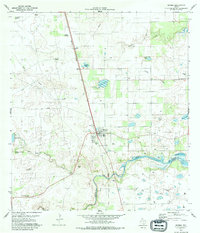
1979 Map of Riviera
USGS Topo · Published 1979About this map
Riviera sits at a critical junction in South Texas, where the Missouri Pacific railroad cuts through the brush country near the Kleberg and Kenedy County line. The settlement pattern here is defined by small, inland water features such as Radicha Lake, Araña Lake, and Seth Waterhole, which supported the region's ranching operations. Numerous family-named windmills, including the Africana Windmill and Rincon de Tio Pancho Windmill, indicate the necessity of groundwater for the livestock economy.
Find a feature on this map
29 named features on this map. Tap any name to fly to it.
Don’t see what you’re looking for? This feature index may not catch every label — zoom into the map to look around manually.
Map Details
Editions of this 1979 Riviera Map
This is the sole edition of this map. No revisions or reprints were ever made.
Other maps of this area

1928 · Sarita
USGS Topo · 1:125,000

1950 · Corpus Christi
USGS Topo · 1:250,000

1952 · Riviera Beach
USGS Topo · 1:24,000

1952 · La Parra Ranch
USGS Topo · 1:24,000

1952 · Riviera Beach NW
USGS Topo · 1:24,000

1952 · Riviera Beach
USGS Topo · 1:62,500

1954 · Sarita
USGS Topo · 1:62,500

1954 · Riviera
USGS Topo · 1:62,500
1955 · La Parra Ranch
USGS Topo · 1:62,500

1956 · Corpus Christi
USGS Topo · 1:250,000