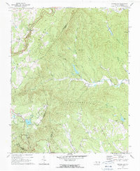
1971 Map of Roaring Gap
USGS Topo · Published 1990About this map
Blue Ridge Parkway curves across the western landscape of this 1971 survey, serving as a high-elevation spine above the deeply dissected terrain of the Blue Ridge escarpment. The map documents a transition from the resort and recreational character of Roaring Gap, with its golf course and Fish Hatchery, to the rural valley communities of Devotion and Doughton. Settled life in the hollows is marked by numerous country sanctuaries such as Antioch Ch and Mitchell River Ch, while family ties to the land are preserved at the Thompson Cem and Walker Cem.
Find a feature on this map
43 named features on this map. Tap any name to fly to it.
Don’t see what you’re looking for? This feature index may not catch every label — zoom into the map to look around manually.
Map Details
Editions of this 1971 Roaring Gap Map
2 editions found
Other maps of this area

1889 · Hillsville
USGS Topo · 1:125,000

1889 · Wytheville
USGS Topo · 1:125,000

1889 · Wilkesboro
USGS Topo · 1:125,000

1891 · Wilkesboro
USGS Topo · 1:125,000

1891 · Yadkinville
USGS Topo · 1:125,000

1892 · Hillsville
USGS Topo · 1:125,000

1892 · Wytheville
USGS Topo · 1:125,000

1893 · Yadkinville
USGS Topo · 1:125,000

1896 · Hillsville
USGS Topo · 1:125,000

1930 · Independence
USGS Topo · 1:48,000