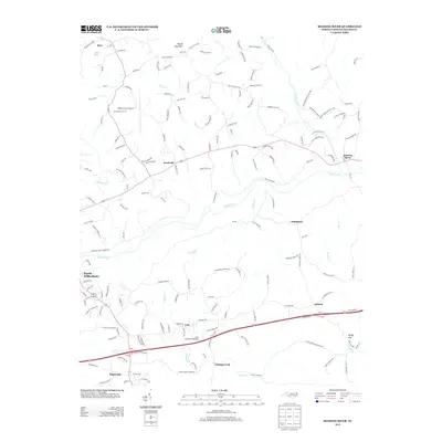
2013 Map of Roaring River
USGS Topo · Published 2013About this map
The Yadkin River and its major tributaries, including Fishing Cr and Roaring River, define the landscape of eastern Wilkes County in this 2013 survey. The area shows a transition from the urbanized edge of North Wilkesboro in the west to more dispersed rural settlements like Knottville, Dellaplane, and Antioch. This map records a dense network of local roads that reflect a history of family landholdings and small-scale agriculture, evidenced by labels such as Anthony Farm Rd and Jim Crabb Rd.
Find a feature on this map
171 named features on this map. Tap any name to fly to it.
Don’t see what you’re looking for? This feature index may not catch every label — zoom into the map to look around manually.
Map Details
Editions of this 2013 Roaring River Map
This is the sole edition of this map. No revisions or reprints were ever made.
Other maps of this area

1889 · Wilkesboro
USGS Topo · 1:125,000

1891 · Wilkesboro
USGS Topo · 1:125,000

1891 · Yadkinville
USGS Topo · 1:125,000

1893 · Yadkinville
USGS Topo · 1:125,000

1953 · Winston-Salem
USGS Topo · 1:250,000

1955 · Winston-Salem
USGS Topo · 1:250,000

1962 · Winston-Salem
USGS Topo · 1:250,000
1966 · Gilreath
USGS Topo · 1:24,000

1966 · Roaring River
USGS Topo · 1:24,000
1966 · Moravian Falls
USGS Topo · 1:24,000