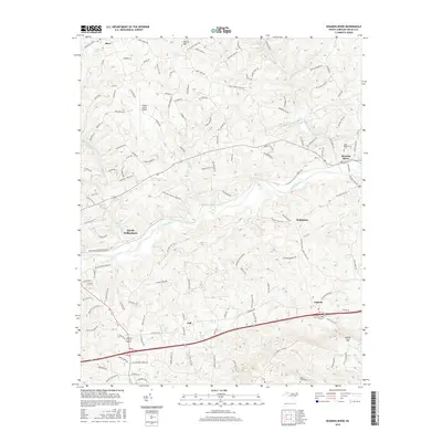
2016 Map of Roaring River
USGS Topo · Published 2016About this map
The Yadkin River serves as the central artery of this Wilkes County landscape, winding between the burgeoning edge of North Wilkesboro and the community of Roaring River. The terrain is defined by the transition from river bottomlands to prominent heights such as Round Mtn in the north and Little Brushy Mtn to the south. Transportation networks are a mix of modernization and older rural routes, including the Wilkes County Airport and arterial highways that connect smaller settlements like Hays, Antioch, and Call.
Find a feature on this map
133 named features on this map. Tap any name to fly to it.
Don’t see what you’re looking for? This feature index may not catch every label — zoom into the map to look around manually.
Map Details
Editions of this 2016 Roaring River Map
This is the sole edition of this map. No revisions or reprints were ever made.
Other maps of this area

1889 · Wilkesboro
USGS Topo · 1:125,000

1891 · Wilkesboro
USGS Topo · 1:125,000

1891 · Yadkinville
USGS Topo · 1:125,000

1893 · Yadkinville
USGS Topo · 1:125,000

1953 · Winston-Salem
USGS Topo · 1:250,000

1955 · Winston-Salem
USGS Topo · 1:250,000

1962 · Winston-Salem
USGS Topo · 1:250,000
1966 · Gilreath
USGS Topo · 1:24,000

1966 · Roaring River
USGS Topo · 1:24,000
1966 · Moravian Falls
USGS Topo · 1:24,000